Tuesday, June 15, 2010
Thursday, May 27, 2010
8-13 by Alex (unfinished.)
8. THERMAL - COAL
production methods
Canada is the fourth largest coal exporter, with over 24 functional coal mines that produced 70 million tons in 2007. This makes up only 1.17% of the world's production. The headquarters are located in Calgary, Alberta and are monitored by The Canadian Coal Association.
where used in Canada
Alberta, British Columbia and Saskatchewan are the three provinces that have working coal mines in Canada. Out of the ten Canadian provinces, only a few of them actually use coal for domestic purposes, and the percentage has been lowered drastically since 2001. New Brunswick, Alberta, Ontario and Quebec have all been known to consume coal for energy purposes, yet Alberta was the number one province for coal consumption in 2001, with 42% of Canada's imported coal.
environmental impacts
The production and consumption of coal both have a toll on the environment. The processing of coal, especially thermal coal can emit toxins into the atmosphere. Harmful gasses such as carbon dioxide and mercury add to the already built up pollution in the air. Not only can the toxins be released into the air, but also by products (such as fly-ash, sludge and bottom ash) that contain arsenic, uranium, mercury and thorium can be spilled into bodies of water or disposed of in unsafe and environmentally unfriendly ways. Acid rain is another effect from the burning of coal. Some gasses from the burning of coal in the air have been proven to have caused lung cancer in citizens, and an overall impact on human health (not to mention animal and plant life, as well.)
9. THERMAL - NUCLEAR
production methods
Nuclear power in Canada produces about 15% of it's electricity. Ontario has the largest nuclear industry in Canada, with 16 operating plants and providing 50% of the provinces nuclear needs. Quebec and New Brunswick have only one nuclear reactor each. Canada was the world's biggest uranium producer for many years, until 2009 when Kazakhstan took over that title.
where used in Canada
Ontario uses nuclear power the most, and this form of energy makes up 15% of the entire countries electrical power, and this power comes from Ontario itself. New Brunswick and Quebec are also known to use nuclear power (as opposed to Hydro Power.) Production of nuclear comes mainly from MacArthur River mine in Saskatchewan
environmental impacts
Like coal, nuclear power has environmental impacts through production, consumption and disposal - also known as the 'Nuclear Fuel Cycle.' Nuclear dispose can become radioactive waste, and the Chemical and Volume Control System (CVCS) has to take care of it and manufacture it to become less dangerous and less harmful before releasing it.
10. ALTERNATE ENERGY SOURCES
(biomass, natural gas, solar, wind, garbage incineration, geothermal)
production methods
Garbage incineration is when the waste is burned at temperatures as high as 900-1000 degrees, and the steam is channeled through tubes to places where it heats up water, and turns into energy. Burning the garbage also cuts down the amount of waste sent to landfills by 90%.
where used in Canada (or world)
Alberta: Alberta Special Waste Treatment Center, Swan Hills. Ontario: Laidlaw, Sarnia. Quebec: Laidlaw Environmental Services, Inc. America also uses incinerators, as well as Germany and many other countries.
environmental impacts
The burning creates an output of gasses and a substance called “flue ash,” which is every bad for our ozone layer. In older incinerators, there is also the concern of “odor pollution.”
limitations
There is much controversy about incinerators because of the gaseous emissions they produce. Although they generate less pollution than coal fired plants, they also produce more than natural gas plants.
11. RECREATIONAL LANDS – PARKS
-overuse and degradation – e.g. Banff
After the war years, Banff National park began attracting many tourists, thus many resturaunts, hotels, golf courses, tourist attractions and expensive billboards and advertisements began to populate the area. After the national highway was constructed, this allowed more tourism to integrate into the area. Many acts and policies have been initiated to maintain and conserve the area, since the original Rocky Mountains Park Act.
conflicts - man vs. animals
There are many animals located in the Banff park, over 280 species of birds, there are caribou, wolves, bears, deer, one species of toad, two species of frog and many other animals. The Banff Springs snail is an endangered species at the moment, as well as caribou and grizzly bears.
12. WASTE DISPOSAL AND RECYCLING
- Three R’s – reduce reuse recycle
the economics of recycling (worth it or not ?)
If we take into account how much more waste there COULD potentially be, recycling seems like a splendid idea. Plastic, paper, cardboard, metal, glass....all of these things are being turned into more reusable substances, recyclable indefinitely. But, recycling plants require energy, and collection of recyclables requires transportation (which requires fuel.) The whole process of recycling, as well as transportation emits emissions and creates waste. Is it worth it to still recycle? Yes. At least we're reusing SOMETHING.
liquid waste – sewage treatment, septic systems, urban run off
Urban and domestic liquid waste (sewage) or other contaminated waters are run in systems to plants where they filter the water generously and clean it, disinfect it and release it again.
landfills, sanitary landfills, incineration – advantages/disadvantages
Landfills are where we ship waste that cannot be recycled or reused. Sanitary landfills are where the waste is isolated from the environment by being buried.. Incineration is when we burn and compress our waste and create a steam that can be used as an energy source, but can still emit pollution and gasses into the ozone layer.
13. WATER MANAGEMENT
- major users of water…agriculture, domestic, industrial
- impacts and solutions for each user
production methods
Canada is the fourth largest coal exporter, with over 24 functional coal mines that produced 70 million tons in 2007. This makes up only 1.17% of the world's production. The headquarters are located in Calgary, Alberta and are monitored by The Canadian Coal Association.
where used in Canada
Alberta, British Columbia and Saskatchewan are the three provinces that have working coal mines in Canada. Out of the ten Canadian provinces, only a few of them actually use coal for domestic purposes, and the percentage has been lowered drastically since 2001. New Brunswick, Alberta, Ontario and Quebec have all been known to consume coal for energy purposes, yet Alberta was the number one province for coal consumption in 2001, with 42% of Canada's imported coal.
environmental impacts
The production and consumption of coal both have a toll on the environment. The processing of coal, especially thermal coal can emit toxins into the atmosphere. Harmful gasses such as carbon dioxide and mercury add to the already built up pollution in the air. Not only can the toxins be released into the air, but also by products (such as fly-ash, sludge and bottom ash) that contain arsenic, uranium, mercury and thorium can be spilled into bodies of water or disposed of in unsafe and environmentally unfriendly ways. Acid rain is another effect from the burning of coal. Some gasses from the burning of coal in the air have been proven to have caused lung cancer in citizens, and an overall impact on human health (not to mention animal and plant life, as well.)
9. THERMAL - NUCLEAR
production methods
Nuclear power in Canada produces about 15% of it's electricity. Ontario has the largest nuclear industry in Canada, with 16 operating plants and providing 50% of the provinces nuclear needs. Quebec and New Brunswick have only one nuclear reactor each. Canada was the world's biggest uranium producer for many years, until 2009 when Kazakhstan took over that title.
where used in Canada
Ontario uses nuclear power the most, and this form of energy makes up 15% of the entire countries electrical power, and this power comes from Ontario itself. New Brunswick and Quebec are also known to use nuclear power (as opposed to Hydro Power.) Production of nuclear comes mainly from MacArthur River mine in Saskatchewan
environmental impacts
Like coal, nuclear power has environmental impacts through production, consumption and disposal - also known as the 'Nuclear Fuel Cycle.' Nuclear dispose can become radioactive waste, and the Chemical and Volume Control System (CVCS) has to take care of it and manufacture it to become less dangerous and less harmful before releasing it.
10. ALTERNATE ENERGY SOURCES
(biomass, natural gas, solar, wind, garbage incineration, geothermal)
production methods
Garbage incineration is when the waste is burned at temperatures as high as 900-1000 degrees, and the steam is channeled through tubes to places where it heats up water, and turns into energy. Burning the garbage also cuts down the amount of waste sent to landfills by 90%.
where used in Canada (or world)
Alberta: Alberta Special Waste Treatment Center, Swan Hills. Ontario: Laidlaw, Sarnia. Quebec: Laidlaw Environmental Services, Inc. America also uses incinerators, as well as Germany and many other countries.
environmental impacts
The burning creates an output of gasses and a substance called “flue ash,” which is every bad for our ozone layer. In older incinerators, there is also the concern of “odor pollution.”
limitations
There is much controversy about incinerators because of the gaseous emissions they produce. Although they generate less pollution than coal fired plants, they also produce more than natural gas plants.
11. RECREATIONAL LANDS – PARKS
-overuse and degradation – e.g. Banff
After the war years, Banff National park began attracting many tourists, thus many resturaunts, hotels, golf courses, tourist attractions and expensive billboards and advertisements began to populate the area. After the national highway was constructed, this allowed more tourism to integrate into the area. Many acts and policies have been initiated to maintain and conserve the area, since the original Rocky Mountains Park Act.
conflicts - man vs. animals
There are many animals located in the Banff park, over 280 species of birds, there are caribou, wolves, bears, deer, one species of toad, two species of frog and many other animals. The Banff Springs snail is an endangered species at the moment, as well as caribou and grizzly bears.
12. WASTE DISPOSAL AND RECYCLING
- Three R’s – reduce reuse recycle
the economics of recycling (worth it or not ?)
If we take into account how much more waste there COULD potentially be, recycling seems like a splendid idea. Plastic, paper, cardboard, metal, glass....all of these things are being turned into more reusable substances, recyclable indefinitely. But, recycling plants require energy, and collection of recyclables requires transportation (which requires fuel.) The whole process of recycling, as well as transportation emits emissions and creates waste. Is it worth it to still recycle? Yes. At least we're reusing SOMETHING.
liquid waste – sewage treatment, septic systems, urban run off
Urban and domestic liquid waste (sewage) or other contaminated waters are run in systems to plants where they filter the water generously and clean it, disinfect it and release it again.
landfills, sanitary landfills, incineration – advantages/disadvantages
Landfills are where we ship waste that cannot be recycled or reused. Sanitary landfills are where the waste is isolated from the environment by being buried.. Incineration is when we burn and compress our waste and create a steam that can be used as an energy source, but can still emit pollution and gasses into the ozone layer.
13. WATER MANAGEMENT
- major users of water…agriculture, domestic, industrial
- impacts and solutions for each user
Saturday, May 22, 2010
Atmosphere
The Atmosphere
Troposphere: This contains approximately 75% of the atmospheres mass. It's depth is around 17 km, and it contains 99% of the atmospheres water vapour and aerosols. The depth can fluctuate depending on where located, in tropical places it is around 20%, yet in polar areas it is only 7%. The troposphere has to do a lot with weather, and the higher you go up, the higher the density and air pressure goes up as well.
Stratosphere: The stratosphere is located above the troposphere and it extends about 50km up. This is the maximum height for aircrafts, and it is both drier and less dense than the troposphere. This layer contains a lot of man released chemicals that tend to stay for long periods of time, and there are little to no clouds because of low water vapour in the stratosphere.
Ozone Layer: The ozone layer is made up of three oxygen molecules (O3), whereas the oxygen we breath is made up of only two. In the stratosphere is located what we call “good ozone” and it blocks harmful UV rays. “Bad ozone” is in the troposphere, and damages humans, vegetation and plants.
Thursday, May 20, 2010
Ocean Currents and Tides
Ocean Currents
1.Currents- This is the transfer of water from one place to another. What generates this process of motion is the air pushing the ocean's surface. Winds catch onto waves and ripples pushing them along. Currents can be reliable upon the temperature and weather as well, such as the temperature from the water at the equator and water from further North and South. This is where the word “gyre” comes into play, when the water moves in a circular motion. In the Northern hemisphere, the water moves in a counter-clockwise motion, and vice versa in Southern Hemisphere. Another factor contributing to currents and their flows is the “salinity” or saltiness of the water, this can make denser water flow in waves.
2.Peru Current on the Coast of Chile: The waves here generate an abundance of fish to live and spawn there, thus making up 18-20 % of the fishing market. The current temperatures here are also quite moderate, not too warm but still allowing some cooler areas.
Gulf Stream on the weather conditions in Newfoundland: Warmer surface waters always seems to move into colder areas. Just like the Labrador current off the coast of Eastern Canada, which is a strong current of warm water that has mixed with colder water. Without currents like these, the earth's sea temperatures would not be regulated and hot latitudes would be much warmer, as well as cold areas MUCH colder.
Tides
1.Causes: Tides are influenced by the gravitational pull of the sun, but more so the pull of the moon. When night falls and the moon is high, the water from the sea is being pulled towards one side of the earth- resulting in a high tide. As the moon rotates around the earth, (in a day) the ocean water is being pulled with it. A spring tide can occur when both the sun and the moon are influencing the tide. A neap tide is when the sun and the moon are pulling at the ocean from opposite directions.
2. How are Tides Beneficial?
Fish is a nutritious food used in many cultures
Marine life- whales, sharks etc can be used for many things. Medicinal purposes, food..
Tides can be helpful to boats as a mean of transportation
Water turbines use tides and currents for electricity.
Tuesday, May 4, 2010
Mass Wasting Examples.
Frank Slide, Alberta
Location: Located near the border of Alberta and British Columbia on Turtle mountain, in the Rocky Mountains. This mountain is known for it's nativity and actually got it's name from the slow rock movement. It's also near the town of Frank- an old coalmine town of the 1900's, which gives us the name “Frank Slide.”
Cause: The mountain is made up of a base of coal and rock sediments, whereas the surface is of dolomite and limestone. Gradually, water began to make its way into cracks in the bottom of the mountain, thus making it unstable.
Occurrence: The whole ordeal took place at about 4:10 am in 1903 on April 29th. The eastern side of the mountain became dislodged and sent large slabs and boulders of rock falling 701 meters down into the valley- completely blanketing it in rock. Some sections of rock were 150 meters deep, 425 meters high and about a kilometre wide.
Damage:
-76 people were killed, 24 people involved survived and only 12 bodies were found.
-The town cemetery and power plant were lost underneath the rock
-The entrance to the coalmine was covered, but 17 of the workers found their way out within a few days.
-Gold creek and Old Man River bridges were demolished.
-Created a lake from blocking the Crowsnest River
- Seven houses were lost underneath it all, outbuildings and many temporary tents were destroyed
- For a month, two miles of the CPR were covered and not in operation.
Aftermath: The government closed down the southern part of the town in 1911, in 1985 an informational centre was built to inform/ educate people about the slide and in 2005 a permanent monitoring system was constructed for the movement of the mountain.
Hope Slide, BC
Location: Located in British Columbia, East of Vancouver city, 12 miles south of the town of Hope on Johnson Peak.
Cause: On January 9, 1965, an earthquake at about3:50 am, and then another earthquake three hours later generated the slide.
Occurrence: The first earthquake generated an avalanche that blocked off the highway in the area. Three hours after the first shock the entire southeast of the mountainside crumbled. There was about 60 million cubic yards of snow, rock, mud, trees and soil tumbled 6000 feet below into the valley. The debris was 200 feet deep.
Damage:
-Outram Lake was destroyed
-two miles of highway were covered
-four people were buried and killed, but only two of the bodies were ever recovered.
Aftermath: The rocks were too deep to be removed to fix the highway, so they built around it.
Portuguese Bend, California
Location: The Palos Verdes Hill in California, Part of a peninsula.
Cause: In the 1950's, after a housing development began construction on a new road. There were many pools and underground pipes, thus meaning it had much groundwater.
Occurrence: August 17, 1956 showed the first signs of an upcoming slide. Cracks were appearing on local buildings and reappearing days after being mended. Roads began to show signs of cracking and distortion. Much of the residential area was damaged by this, 7-10 cm of movement occurred every day.
Damage: Much construction work was needed to repair the residential damage, but nobody died.
Aftermath: People no longer live in this area, and many water pipes and groundwater had to be removed.
Wednesday, April 21, 2010
Causes/ Solutions Mass Wasting
CAUSES
Shocks: These can be major- like the sudden shock of an earthquake, or they can be minor, caused by the wind or simply by a vehicle driving down the road. Shocks can trigger the side of a slope to become unstable, unsafe, and possibly trigger avalanches, mudslides, etc.
Slope Modification: The steepness of the slope can vary, and can be modified by man or even natural causes. This can modify how much mass wasting actually occurs.
Undercutting: This is what happens when flowing water (like a stream of river) erodes away at a slope, thus causing it to become unstable.
Precipitation: It depends on the area and circumstances, precipitation can either cause much damage with heavy, long lasting rainfall, or minor damage- only moving soil and aiding future mass wasting.
Volcanic Eruptions: Volcanic eruptions cause a lot of damage. They can be a shock, thus causing an earthquake, and molten lava makes things move (and melts ice, triggering more disaster)- mudslides and landslides, possibly rock slides as well.
SOLUTIONS
-Building and maintaining screens and cables to stop/contain rock falls
-Constructing walls and barriers
-Keeping heavy weight off the top of a slope, not adding unnecessary weight
-Being careful with water saturation levels in soil
-Monitoring how much removal of vegetation and roots- this loosens soil
-Not undercutting at the base of slopes
-Planting more vegetation
-Drain pipes for excess water
-Terracing slopes to make them less steep
Tuesday, April 20, 2010
Types of Mass Wasting.
TYPES OF MASS WASTING
Soil Creep- A slow, gradual slide of loose rock and soil on a slope.. You cannot actually see it happen, but you can see the effects such as tilted fences, walls and tree trunks. This usually occurs in humid areas, and can be worsened by freezing, thawing, wetting and drying.
Slump- When large amounts of rock/ boulders are forced to move down a hill slowly by a block.
Solifluction- This is like a mudslide. It is found in moist, humid areas, where soil, rock and water have mixed and the land literally moves like a thick liquid downhill.
Flows – Earth Flow, Mudflow- Rapid movement of large masses of mud made up of water and soil.
Talus Creep- Created by a fall, this is a cone shaped pile of debris.
Slide –Rockslide- This is when large pieces of rock break loose from the side of a mountain, and rapidly slide downhill.
Avalanche – This is a rapid flow/slide of ice, rock, snow and earth down a slope.
Fall – Rock fall- When bits and pieces of individual rock fall down the side of a mountain, creating a fan or triangle shaped pile at the base.
Groundwater Statistics.
Groundwater is the water found underneath the surface of the earth. Artesians lead from the fresh water to the surface, thus many people around the world rely on it for many purposes, such as drinking water, bathing water, cleaning water..etc.
your local community- In British Columbia, 28.5 % of the population uses groundwater for multiple purposes.
Country- In Canada as a whole, 30.3% depend on groundwater for many purposes.
the earth as a whole-
The earth as a whole: Around 20% of the earth relies on groundwater as their freshwater supply.

An artesian well works simply by gravity. An artesian well works because the water is usually flowing from a point of high elevation, it moves through porous rock layers to the surface because of the pressure from the rock.
Human impact on groundwater can contaminate groundwater in various ways- from surface sourses, ground sources and other sources as well. Having landfills and dumps for waste water, leakages in petrol tanks and sewage systems, and the use of pesticides on agriculture can greatly impact the safety of the water supply.
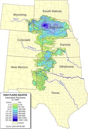
The Ogallala Aquifer is the worlds largest aquifer, covering an area of 450, 000 square kilometres. It is also known as the High Plains Aquifer, and it is used 30% for irrigation purposes and is a drinking water supply to 82% of the population. It is located in the Great Plains of the United States of America.
The Urban Water Cycle (UWC) is a project run by the countries around the North Sea (Germany, Holland, England and Denmark) to tackle the drinking water problem. They all share ideas and solutions about this problem and discuss ways to preserve water for the future.
In Walkerton, Ontario in May of 2008, the local drinking water supply was contaminated by a nearby farm run off into a nearby well with the bacteria E.coli. Around 5000 people of the town were infected. 7 of these people died because the town did not admit to the problem as soon as they should have.
your local community- In British Columbia, 28.5 % of the population uses groundwater for multiple purposes.
Country- In Canada as a whole, 30.3% depend on groundwater for many purposes.
the earth as a whole-
The earth as a whole: Around 20% of the earth relies on groundwater as their freshwater supply.
An artesian well works simply by gravity. An artesian well works because the water is usually flowing from a point of high elevation, it moves through porous rock layers to the surface because of the pressure from the rock.
Human impact on groundwater can contaminate groundwater in various ways- from surface sourses, ground sources and other sources as well. Having landfills and dumps for waste water, leakages in petrol tanks and sewage systems, and the use of pesticides on agriculture can greatly impact the safety of the water supply.
The Ogallala Aquifer is the worlds largest aquifer, covering an area of 450, 000 square kilometres. It is also known as the High Plains Aquifer, and it is used 30% for irrigation purposes and is a drinking water supply to 82% of the population. It is located in the Great Plains of the United States of America.
The Urban Water Cycle (UWC) is a project run by the countries around the North Sea (Germany, Holland, England and Denmark) to tackle the drinking water problem. They all share ideas and solutions about this problem and discuss ways to preserve water for the future.
In Walkerton, Ontario in May of 2008, the local drinking water supply was contaminated by a nearby farm run off into a nearby well with the bacteria E.coli. Around 5000 people of the town were infected. 7 of these people died because the town did not admit to the problem as soon as they should have.
Monday, April 19, 2010
Oh, cool.

This doesn't have to do with Salt Spring Island Water, but it's pretty interesting nonetheless.
Thursday, April 15, 2010
River and Streams Terms
Rivers
Youthful stream –The beginning stages of a river. A matured stream that has returned back to youthful habits due to an uplift or rejuvination.
V-shaped valley- A valley with cross-sectional structure in the shape of a v, usually created by river erosion.
Evapotranspiration- the amount of water evaporation and plant transpiration from the Earth's land to the atmosphere.
Headward Erosion- the lengthening of a young valley or gully by water erosion at the head of the valley.
Vertical Erosion- When the depth of the river is greater than the width, causing erosion to take place on the bed of the river.
Lateral Erosion- When the water erodes the sediments on the stream channel.
Flood Plain- A plain bordering a river that is at possibility of flooding.
Precipitation- the water that has evaporated into the air, after it falls.
Alluvium- Sediment deposited by flowing water in riverbeds, floodplains or deltas.
Meander- A stream that follows a winding, turning course.
Undercut Banks/Slip-off Slopes- Strong flow of water against an Earthen bank that can create cave like forms and overhangs. (Slip off slopes: the low, gentle overhang on the inside of the downside face of a stream.)
Old Age stream- River that has almost reached it's base level, thus making it slow, and gradient and velocity very low.
Levees- natural or artificial wall or slope used to regulate water levels.
Oxbow Lakes- A U shaped body of water created by river that is cut off to make a lake.
Yazoo Streams- A stream that runs parallel to, and sometimes within the floodplain of, a river.
Solution-
condensation- The procedure of moisture (or a gaseous matter) solidifying into a liquid or solid state.
Suspension-
Traction/Saltation- Process of particle transportation by water.
Abrasion/Corrasion The weathering down by boulders and pebbles crashing against the shore rocks or sea cliffs. This can cause undercutting.
Attrition- Boulders or pebbles crashing against the shore themselves breaking.
Evaporation- The process of water turning into a gaseous form- mist/ moisture.
Corrosion- Materials dissolved by seawater.
Hydraulic Action- A form of erosion caused by moving water rushing into a crack in the riverbed, leaving air in it, and acting like a wedge. When the water exits the cracks, they grow bigger.
Water Shed- A ridge of high landing dividing two areas that are drained by different river systems.
Tributaries- A stream. River or glacier that feeds a larger one.
Distributaries- A branch or stream that flows away from the river, and doesn't return to it.
Confluence- A flowing together of two or more streams.
Transpiration- Emission of water vapor through the leaves of plants.
Interfluve- The region of higher land between two rivers of the same level and drainage system.
Divide- Kind of like a watershed- the area of high land that separates draining basins.
Hydrologic Cycle- Another name for “water cycle” the cycle of evaporation, precipitation, etc.
Paired Terraces- Also known as a “matched terrace”, it is two stream terraces that face eachother at opposite sides of the stream from the same elevation and represent same remnants from a floodplain or valley floor.
Alluvial Fan- Cone- shaped deposit of sediments left by a fast flowing river that runs onto a a level plain, valley floor or basin abruptly.
Arcuate Delta- A bowed or curved delta with the convex area facing the water.
Birds foot Delta- A delta with long, projecting branches that spread out like birds talons.
Cuspate Delta- Pointed, shaped by gentle water opposing it.
Estuary- Partially enclosed coastal body of water, usually with a connection to the ocean, where salt and fresh water mix.
Braided Stream- A stream flowing in several channels that weave.
Run off- the water that just runs over the ground, usually after a heavy rainfall.
Groundwater- Water that is found underneath the surface of the earth.
Trellis- a weaved structure of wood usually used to support plant life?
Radial- Branching out in all directions with a common center.
Dendritic- Drainage pattern of a stream or river, like a tree, branching out.
Deranged- To upset/ disturb the arrangement of things
Mature stream- A river with a gradient less steep and slower flowing than a youthful one.
Tuesday, April 13, 2010
Desert 2
GEOGRAPHY 12
DESERT LANDFORMS part 2
Despite the fact that water is the most important agent of erosion in deserts, wind is quite important too.
The action of wind eroding, transporting and depositing sediments is called eolian or aeolian erosion processes.
Wind erosion is common because there is little soil to hold the sand or sediment in place.
Deflation is the large scale removal of sediment by wind.
Abrasion is the process where sand carried by the wind “sandblasts”
rocks
Regions covered in sand are called ergs, or sand seas.
Regions which are bare rock are called gibbers, serir, or regs in Algeria.
Diagram and explain the following:
Deflation hollow or basin:
Created by wind erosion, the wind whips sand at sand-sediment structures periodically thus carving out a hollow.
Barchan- arc-shaped sand ridge/ dune of well-sorted sand, with two “horns” facing the opposite direction of the wind.
Parabolic dunes- Carved and molded dunes do to wind erosion.
rock pedestal- This is the product of wind erosion when small sand sediments carve away at the base of a mound, leaving the harder rock in place, creating a sort of “pedestal.”
arch- Often an enlarged cave or opening carved out by waves or wind.
salt flats- This is what happens when water evaporates, leaving the remnants of salt behind on a plain after a rainfall.
Badland- A landscape full of gullies, carved hillsides and ravines eroded down by wave action into relatively soft rock/ arid climate.
Desert 1
Geography 12
DESERT LANDFORMS
Deserts - def. - arid region characterized by little or no rainfall in which vegetation is scanty or absent unless specially adapted
region where evaporation exceeds precipitation
There are various causes of deserts -
1) Continentality - the desert is far from a body of water or the influence of a
body of water - e.g. Gobi desert
2) High Pressure - in subtropical regions descending air in high pressure belts
prevents moist air masses from entering the area and bringing rainfall
e.g. Sahara
3) Rainshadow- regions on the leeward side of mountains experience dry
conditions due to adiabatic heating of descending air masses e.g. Mojave
4) Cold Ocean currents - on the west coasts of S. America and S. Africa cold
currents create stable air masses that hold very little water vapour - as the
air mass meets the warmer land mass fog forms but there is not enough
water vapour to create precipitation - e.g. Atacama
5) Polar deserts - created by sinking of cold dry air masses - ice is present
on the land although there is little precipitation
DESERT LANDFORMS
Despite the lack or limited amount of precipitation in deserts, water is the major agent of erosion. Rainfall when it comes is brief and intense, and due to the hard rocky surface and limited vegetation tends to quickly run off,
creating flash floods.
Landforms created by water include: (define and draw)
Wadis – Common water-formed features in desert regions. They have steep sides, and don't usually contain flowing water. Most of the damage is done by flash floods.
Playas – Dry lake beds imbedded with clays and silts. After a rainfall, as the water evaporates, it leaves behind remnants of solid salts and such. These dry lake beds are usually found in the centre of inland basins.
Alluvial fans – This is where large sediments previously carried by running water has built up abruptly on level plains, valleys or basins. This usually occurs between mountains, and causes a drop in stream velocity and depth.
Bahada – Linked closely to alluvial fans, this is a gently sloping surface of alluvial materials from the foot of a mountain to the centre of a basin. These are formed by build up of alluvial fans.
Mesa/ Butte – A butte is smaller than a mesa, a flat topped hill with steep sloped sides. A mesa is a bigger version of this, with escarpments marking the sides.
Canyon – A ravine caused by a river, in an area of seldom rainfall.
Because of limited precipitation physical weathering is dominant.
The main physical processes are heating-cooling, freezing-thawing,
and exfoliation.
DESERT LANDFORMS
Deserts - def. - arid region characterized by little or no rainfall in which vegetation is scanty or absent unless specially adapted
region where evaporation exceeds precipitation
There are various causes of deserts -
1) Continentality - the desert is far from a body of water or the influence of a
body of water - e.g. Gobi desert
2) High Pressure - in subtropical regions descending air in high pressure belts
prevents moist air masses from entering the area and bringing rainfall
e.g. Sahara
3) Rainshadow- regions on the leeward side of mountains experience dry
conditions due to adiabatic heating of descending air masses e.g. Mojave
4) Cold Ocean currents - on the west coasts of S. America and S. Africa cold
currents create stable air masses that hold very little water vapour - as the
air mass meets the warmer land mass fog forms but there is not enough
water vapour to create precipitation - e.g. Atacama
5) Polar deserts - created by sinking of cold dry air masses - ice is present
on the land although there is little precipitation
DESERT LANDFORMS
Despite the lack or limited amount of precipitation in deserts, water is the major agent of erosion. Rainfall when it comes is brief and intense, and due to the hard rocky surface and limited vegetation tends to quickly run off,
creating flash floods.
Landforms created by water include: (define and draw)
Wadis – Common water-formed features in desert regions. They have steep sides, and don't usually contain flowing water. Most of the damage is done by flash floods.
Playas – Dry lake beds imbedded with clays and silts. After a rainfall, as the water evaporates, it leaves behind remnants of solid salts and such. These dry lake beds are usually found in the centre of inland basins.
Alluvial fans – This is where large sediments previously carried by running water has built up abruptly on level plains, valleys or basins. This usually occurs between mountains, and causes a drop in stream velocity and depth.
Bahada – Linked closely to alluvial fans, this is a gently sloping surface of alluvial materials from the foot of a mountain to the centre of a basin. These are formed by build up of alluvial fans.
Mesa/ Butte – A butte is smaller than a mesa, a flat topped hill with steep sloped sides. A mesa is a bigger version of this, with escarpments marking the sides.
Canyon – A ravine caused by a river, in an area of seldom rainfall.
Because of limited precipitation physical weathering is dominant.
The main physical processes are heating-cooling, freezing-thawing,
and exfoliation.
Tuesday, March 30, 2010
Weathering and Erosion
GEOGRAPHY 12
WEATHERING and EROSION NOTES
Text: Planet Earth pp 240 – 251
Landforms result from the uplift caused by tectonic forces and the processes of denudation (or LEVELLING).
The processes of denudation work to reduce land to BASE LEVEL, the lowest level to which a land surface can be eroded.
Denudation ca be divided into two categories:
1) DEGRADATION includes the processes of:
A) WEATHERING(breaking up of rock near or at earth’s surface)
B) EROSION (removal and movement/transport of rock debris)
2)AGGRADATION (building up of land surface by deposition of rock materials – this occurs when a drop in energy SLOWS the transporting agent…e.g. rivers slow down at BASE LEVEL.)
Weathering
reduces rocks to smaller particles
provides PARENT MATERIALS for the process of soil formation
Weathering can be divided into two types:
MECHANICAL or physical weathering is the breaking up of rocks without any change to their chemical composition
Examples of Physical/Mechanical Weathering
FROST SHATTERING or ICE WEDGING- water seeps into cracks and joints, freezes and splits the rock apart
THERMAL EXPANSION - rocks composed of different crystals contract and expand with temperature change at different rates…this causes the rocks to eventually disintegrate
3)PRESSURE RELEASE (sheeting) or pressure release is the separation of layers in granite due to the removal of overburden and the release of pressure…these features often form rounded exfoliation domes
4) Animals and plant roots can also weather rock.
5) In deserts, evaporation leaves behind salt CRYSTALS in rock pores and fissures. As these grow they can wedge rocks apart.
Chemical Weathering is the break up of rocks due to A CHANGE IN THE CHEMICAL COMPOSITION OF THE MINERALS IN WHICH MAKE THEM UP .
SOLUTION - rainwater, which is naturally weakly acidic, reacts with SOLUBLE minerals, dissolving them and carrying them away.
LIMESTONE, a commonly used building material is very prone to solution.
OXIDATION - the process of combining oxygen with a mineral.
HYDROLYSIS - ions of water replace ions of a mineral which produces amongst other things, clays.
The rate of weathering depends on a number of factors.
Explain how the following factors may contribute to the rate and amount of weathering:
Nature of bedrock – THE COMPOSITION OF IT, SIZE OF IT, JOINTS.
Temperature - COLD AND DRY, WARM AND MOIST, SHOWS WHETHER IT'S MORE CHEMICALLY OR PHYSICALLY ERODING.
3) Precipitation – THE AMOUNT OF RAINFALL, HOW MOIST/ DENSE THE AIR IS. HOW MUCH SNOW (IF ANY).
4) Slope/drainage – HOW MUCH WATER BUILD UP, BLOCKAGE, HOW MANY RIVERS/STREAMS TO CARRY SEDIMENTS AWAY.
We can generalize where chemical and physical and mechanical weathering are predominant:
Chemical weathering is most common in area that are …
Warm and moist, like California.
Mechanical/physical weathering is most common in area that are …
Cold and harsh, places with lots of hard rain, snow and ice.
Monday, March 29, 2010
Earthquakes, Folds and Faults.
Earthquakes, Folds and Faults.
1. Explain the relationship between earthquakes and plate tectonics. When certain tectonic plates have specific boundaries (such as transform faults and such) this can create tension build up. When the pressure is released, the tectonic plates will shake.
Why do earthquakes occur at places NOT on plate boundaries? Because it's not actually happening at the fault- it happens at the epicenter (the point on the ground directly above the focus, or hypocenter.)
2. Create labeled diagrams of the major types of faults - normal, reverse, overthrust, transform. Be sure to label movement direction and forces acting on the blocks.
Reverse: http://facweb.bhc.edu/academics/science/harwoodr/GEOL101/study/Images/ReverseFault.gif
Overthrust: http://wpcontent.answers.com/wikipedia/commons/c/ce/Fault-propagation_fold.gif
Transform: http://www.freewebs.com/morganisrupert/4_1.jpg
3. Describe the dangers associated with earthquakes. Earthquakes cause major structural damage, can initiate tsunamis and generate volcanoes, as well.
4. Diagram the major types of folds - anticline, syncline, dome, geosyncline.
Anticline: http://upload.wikimedia.org/wikipedia/commons/b/b6/Anticline_(PSF).png
.png)
Syncline:http://www.eoearth.org/upload/thumb/4/4e/Syncline_fold_diagram.gif/250px-Syncline_fold_diagram.gif
Dome: http://facweb.bhc.edu/academics/science/harwoodr/GEOG102/Study/images/Dome.gif
Thursday, February 11, 2010
Structure of the Earth
Please define/ explain the significance of these in regards to plate tectonics:
1. Lithosphere: outer part of the earth consisting of crust and the mantle. This is what the plates are made out of, what moves.
2. Oceanic Plates: tectonic plates that are underneath the water, still moving, and made up of more sulphur than continental plates. This makes them less dense and easier to submerge under the continental plates.
3. Continental Plates: The tectonic plates that are above sea water. They are denser than oceanic ones.
4. Asthenosphere: This lays underneath the lithosphere, it consists of molten rock. This is what the lithosphere (tectonic plates) move on top of.
5. Convection currents: This is the process of the heat movement in the asthenosphere that generates the tectonic plates movement.
Tuesday, February 9, 2010
Plate tectonics
PLATE TECTONICS STUDY GUIDE
1. CONTINENTAL DRIFT
Main idea – Pangea once existed, a super-continent where all the continents were one, until something happened to make them crack and drift apart.
Evidence – Mountain ranges, volcano chains, similar plant and animal fossils, “jigsaw-like fit” of continents, weather patterns (history of erosion and opposite weathering from the current ie. Glacier erosion in a tropical place)
Why was Alfred Wegener laughed at ? He proposed the idea of continental drift without much evidence, other than the “jigsaw-like fit” of all the continents. The argument against Wegener was that it was not “possible for some of the earths crust to be solid, and some to be liquid, or molten.”
2. PLATE MOVEMENT
What is the lithosphere ? The hard and rigid outer layer of the earth. The upper mantle and crust.
Explain the differences between a oceanic plate and a continental plate
An oceanic plate is the plate underneath the water, and a continental plate is one of which is exposed above the water. The continental plate is much thicker and made of granite, and they have also been around for much longer. Whereas the oceanic plate is composed of mainly basalt, making them thinner.
What is the asthenosphere ? The asthenosphere is a molten zone located beneath the lithosphere and is composed of plastic properties.
How does it make plates move ? Convection currents make the plates move, where the molten earth is moving in such a way that it makes the lithosphere on top roll along (very slowly.)
How fast do the plates move ? Very slowly, some plates only move two centimeters per year. In some cases, when there is pressure built up between two subducting plates, when the pressure is released, it results in an earthquake.
Name two natural disasters/phenomenon associated with plate boundaries and movement.
Subduction plate boundaries result in earthquakes, whereas diverging plate boundaries result in volcanoes and trenches.
3. Evidence of plate movement
coastline fit – West coast of Africa and East Coast of South America seem to fit together.
geologic fit – The Himalayas continue from one continent to another in a broken mountain chain range.
Paleoclimatology – The climate change on the continent. A once polar place ( complete with glacier and ice erosion from millions of years ago) can now be a tropical place. This can also deal with tree rings, ocean sediments, radiocarbons in organic material...etc.
fossil correlation – Fossils of plants and animals have been discovered oceans away from eachother.
age of sea floor – the different rock minerals and compositions and changes due to the magnetic polar shifts throughout time.
paleomagnetism – The polar shifts create a pattern along the sea floor, in the magnetic minerals.
What was PANGAEA ? - A super continent millions of years ago, before it split and the continents moved.
4. TYPES OF PLATE BOUNDARIES - labeled diagrams - NAME AN EXAMPLE
Divergent boundaries -
a) seafloor spreading: hot spots
b) continental rifting: Great East African Rift Valley, the Nubian Plate and Somali Plate
Convergent Boundaries -
a) continent/continent: The Juan De Fuca plate beneath the North American plate is an example. This is a transfom boundary, where one continental plate grinds against another and pushes the crust upwards. This creates mountain chains and volcanoes.
b) ocean/continent: This is where an ocean plate submerges beneath a continental plate, creating trenches and such.
c) ocean/ocean: This is where one of the oceanic plates submerges under the other and creates deep trenches.
Big Important summary question - How has plate tectonics affected Canada and its landforms ?
Plate tectonics are affecting Canada and other countries massively. In Canada, there are many mountains and volcanoes that are the result of moving plate tectonics. Although dormant, Mount Garibaldi and Mount Meager are caused by a subduction zone. There is a spreading ridge just off the coast of Vancouver Island (The Juan De Fuca Plate). The Northwestern corner of Canada is going through some stretching due to a spreading ridge as well. This is weakening the earths crust. There are also hot spots along the coast of Canada- such as the Nazko Cone in British Columbia.
Monday, February 8, 2010
Volcanoes pt. 1
GEOGRAPHY 12
TEXTS
Knapp Worral pp. 6 - 22
Smythe Brown pp. 99 - 108
Physical Geology pp. 169 - 195
1. Explain how the folowing terms differ:
LAVA vs. MAGMA
Lava is thick and reaches the earths surface, whereas magma is the molten rock inside the earth which is a little thinner than lava.
DORMANT vs. EXTINCT volcanoes
Dormant volcanoes are inactive, but not extinct. There is still a chance that it may erupt in the future, whereas extinct volcanoes are completely incapable of future eruptions.
INTRUSIVE vs. EXTRUSIVE Volcanism
An intrusive volcano is one which erupts INSIDE the earth. An extrusive volcano has an opening on the earths surface- such as a rift or a cone shaped mountain.
VOLCANOES vs. HOT SPOTS
A volcano has an opening above sea level, such as a composite volcano. A hot spot is where magma pushes its way through the crust to erupt on the sea floor or the ground of the earths crust, which creates a sheild volcano.
2. Explain where volcanoes tend to be located.
Volcanoes tend to be located at the edges of tectonic plates. When a plate is converging and creating a cone-shaped volcano, sometimes lava gets pushed up through the neck of the volcano. At divergent plate boundaries, where the plates are seperating and creating a trench, lava may bubble up, or when one plate is subducting under another, a rift volcano may occur.
3. What and where is the "RING OF FIRE"?
The ring of fire is located in the Pacific, stretching from New Zealand, along the Eastern Edge of Asia, North across some Alaskan Islands and South along the coast of North and South America.
4. Complete the following chart for the 3 main types of volcanoes:
volcano type appearance
Composite /cone shaped/ built up of solidified lava and rock sediments/Subduction zones/ Mount Rainier
Sheild/ massive, broad, gently sloped dome/ build up of hot spot lava/ seafloor, divergent zones/ Hawaii
Compound/ two or more vents/ multiple eruptions from sides, build up of ash and solid lava/ Along plate boundaries/ Homa Mountain, Kenya
5. Define the following terms and create an original diagram showing all of the features.dike – sheet intrusion that cuts across massive rock formations or compositions.
sill – flat, horizontal mass of igneous rock in between two layers of older sedimentary rock formations.
laccolith – an intrusion of igenous rock (molten magma at the time) in between two layers of sedimentary rock. This intrusion pushes the overlying rock up, creating a dome-like appearance on the crust of the earth.
batholith – A large mass of igenous rock believed to have solidified beneath the earth.
pipe (neck) – The throat inside volcanoes that brings the lava to the surface.
geyser – A spring that discharges hot water and steam.
6. Using the PHYSICAL GEOLOGY text complete the following chart:
HAZARD
lava flow/ it’s fast, can burn anything./ Run, don’t live near volcanoes, use ocean water to spray onto oncoming lava.
Pyroclastics/ cinders, ash, gas./ Create a synthetic winter, block sun./ Nothing. Don’t live near a volcano.
Nuee Ardentes( pyroclastic flows)/ flow of hot gas, rock and ash./ Get out of it’s way.
Lahars/ Landslide flow of hot mud, water and pyroclastics/ It’s very fast, run.
toxic gases/ The toxic gases released from a volcano/ stay away from the opening of a volcano.
steam explosions/ sometimes accompanied by pyroclastics, toxic gases/ don’t live near a volcano.
Wednesday, February 3, 2010
The Five Themes of Geography
Saltspring Island
Location-
Absolute: 48 45' /123 30'
Relative: Located in the Southern Gulf Islands, below Kuper Island, Galiano Island, Wallace Island, to the West off the Coast of Vancouver Island, between the Tricomali Channel and the Stuart Channel in the Pacific Ocean. Located to the East is Vancouver Island, to the North is Mainland Vancouver- 20-35 minutes ferry travel to Vancouver Island, and about an hour and a half to mainland Vancouver. Close to the 49th parallel, or the US/Canada border.
Place-
Physical characteristics: Saltspring is 185 sq. km, 72 sq miles. There are several lakes: Saint Mary Lake, Maxwell Lake, Cushion Lake, Stowel Lake, Ford Lake, Roberts Lake, and Bullock Lake. There are many mountains as well: Mount Erskine, Mount Maxwell, Mount Belcher, Mount Sullivan, Mount Tuam, Mount Bruce, Hope Hill, and Reginald Hill. There are 29 beaches in total, 9 swimming beaches: Arbutus Beach, Hudson Point, Fernwood Point, Long Harbour Beach, Churchill, Price Beach, Beddis Beach, Ruckle Beach, Isabella Point, Burgoine Bay, Erskine Bay, Baker Beach and Vesuvius Beach. Other Physical characteristics include: Eleanor Point, Isabella Point, Cape Keppel, Musgrave Landing, Bold Bluff, Burgoyne Bay, Maxwell Point, Booth Bay, Southey Point, Hudson Point, Athal Peninsula, Nose Point, Scott Point and Yeo Point.
Cultural/ man-made characteristics:
Saltspring contains a few ferry terminals and boating ports: Long Harbour Terminal, Vesuvius Terminal, Fulford Harbour as well as several public docks- such as the one located in Ganges. Major roads: Fulford- Ganges Road, Beaver Point Road, Steward Road, Beddis Road, Robbinson Road, Vesuvuis Road, Sunset Drive, Lower Ganges road as well as many others. Saltspring has many parks: Ruckle Park, Arnell Park, Maxwell, Mouat Park, Beaver Point Park, Drummond Park, and Portlock. The schools: Saltspring Elementary, Fulford Elementary, Fernwood Elementary, Pheonix Elementary, Center School, Gulf Islands Middle School, Gulf Islands Senior Secondary School, and Pheonix High. Other: Library, 225 farms, 1 fairground, 7 public docks, 4 commercial marinas, 3 post offices, 3 firehalls, 7 community halls, 1 movie theatre, 16 churches, 1 hospital, 2 golf courses, 1 swimming pool, 5 tennis courts, 2 major grocery stores, 2 major shopping centers, 16 resturaunts, 15 cafes, 2 pubs, 1 hotel, 1 motel, 4 gas stations and many resorts, bed and breakfasts, and cottages.
Region/ Cultural:
North America, Canada, Westcoast, Southern Gulf Islands. Saltspring is a part of the Pacific Rim and is a Southern Gulf Island located in the Strait of Georgia between Vancouver Island and Mainland Vancouver. It is also part of the Capital Regional District along with Municipalities of Greater Victoria.
Human/Environment Interactions:
Saltspring is located on the North American tectonic plate, on top of the submerging Juan De Fuca plate- this is a potential natural earthquake hazard. Forest fires are reoccurant during the summer, and hard to extinguish due to the hardship of getting help over to the island.
One of the environmental changes Saltspringers have made ot the island is draining and filling Swanson's Pond in order to have more space for residential housing developments. The placement of Aeraters into the St. Mary lake to suppress the growth of a certain fungi is another, as well as containing a potential avalanche area with synthetic grass and tree growth along a road leading to Fulford Harbour. Foresting on he mountains to create more residential area, the development of ferry terminals and public docks to make transportation more convenient and the creation of paved or gravel roads for on-island transportation.
One major environmental concern is rising sea levels. Because of global warming, the ice caps could melt and the sea levels would rise significantly, burying Saltspring under a blanket of sea water.
Movement-
The ferry terminal in Vesuvius can take you to Crofton in twenty minutes. The ferry terminal in Fulford can take you to Sidney in thirty five minutes. The ferry terminal in Long Harbour can get you to the Lower Mainland and outer Islands in anywhere from one to three hours. There are also three seaplanes that can take you to the mainland and Vancouver Island. For off island students attending Gulf Islands Senior Secondary, there is a water taxi that runs twice a day picking up and dropping off students from Pender, Galiano, Mayne and Saturna Island. It takes anywhere from thirty mintutes to forty five minutes, and they also run occasionally in the summertime.
Saltspring gets their electricity from BC Hydro, solar power and in some cases- wind power.
There are over 200 farms and greenhouses on Saltspring Island that sell their goods on the side of the road by the honor system, as well as two major grocery markets. A lot of the products we get off the shelves of our grocery store are shipped to the store by vessels from the mainland, but there is some produce, sea food, deli cheeses and meat (such as lamb) that is from the island itself. Things that are shipped to the island are usually from mainland BC or Vancouver Island, from Cowichan Valley.
Because BC is known for it's foresting and fishing, there's not many manafacturing plants for material products. Because of the size of Saltspring, it is hard to share the resources because we use them for our own sustainability. Some local artists may ship or sell their work, but it isn't very common.
For islanders, many houses have their own septic tanks, but on smaller streets houses may share tanks. For recyclable items, the island has a recycling depot and as for industrial waste, there is a dump on the island as well, but most garbage is shipped off island to bigger dumps.
Saltspring Island is very art-oriented. There are many local artists, musicians and authors who share their work on the island. This attracts other cultures and maintains ties with other places as well. We host art shows, we have a small venue called "Beaver Point Hall" where artists come and perform, and there are poetry readings held around Ganges on certain nights. The fact that we are a part of Western Canada connects us to Native culture as well. In the high school, GISS, there are many exchange programs for students through grades 10-12, such as students from Germany, Japan, Austria and many other places. The first Japanese settlers to discover the island have had some impact on it's growth culturally as well.
Subscribe to:
Posts (Atom)