CAUSES
Shocks: These can be major- like the sudden shock of an earthquake, or they can be minor, caused by the wind or simply by a vehicle driving down the road. Shocks can trigger the side of a slope to become unstable, unsafe, and possibly trigger avalanches, mudslides, etc.
Slope Modification: The steepness of the slope can vary, and can be modified by man or even natural causes. This can modify how much mass wasting actually occurs.
Undercutting: This is what happens when flowing water (like a stream of river) erodes away at a slope, thus causing it to become unstable.
Precipitation: It depends on the area and circumstances, precipitation can either cause much damage with heavy, long lasting rainfall, or minor damage- only moving soil and aiding future mass wasting.
Volcanic Eruptions: Volcanic eruptions cause a lot of damage. They can be a shock, thus causing an earthquake, and molten lava makes things move (and melts ice, triggering more disaster)- mudslides and landslides, possibly rock slides as well.
SOLUTIONS
-Building and maintaining screens and cables to stop/contain rock falls
-Constructing walls and barriers
-Keeping heavy weight off the top of a slope, not adding unnecessary weight
-Being careful with water saturation levels in soil
-Monitoring how much removal of vegetation and roots- this loosens soil
-Not undercutting at the base of slopes
-Planting more vegetation
-Drain pipes for excess water
-Terracing slopes to make them less steep
Wednesday, April 21, 2010
Tuesday, April 20, 2010
Types of Mass Wasting.
TYPES OF MASS WASTING
Soil Creep- A slow, gradual slide of loose rock and soil on a slope.. You cannot actually see it happen, but you can see the effects such as tilted fences, walls and tree trunks. This usually occurs in humid areas, and can be worsened by freezing, thawing, wetting and drying.
Slump- When large amounts of rock/ boulders are forced to move down a hill slowly by a block.
Solifluction- This is like a mudslide. It is found in moist, humid areas, where soil, rock and water have mixed and the land literally moves like a thick liquid downhill.
Flows – Earth Flow, Mudflow- Rapid movement of large masses of mud made up of water and soil.
Talus Creep- Created by a fall, this is a cone shaped pile of debris.
Slide –Rockslide- This is when large pieces of rock break loose from the side of a mountain, and rapidly slide downhill.
Avalanche – This is a rapid flow/slide of ice, rock, snow and earth down a slope.
Fall – Rock fall- When bits and pieces of individual rock fall down the side of a mountain, creating a fan or triangle shaped pile at the base.
Groundwater Statistics.
Groundwater is the water found underneath the surface of the earth. Artesians lead from the fresh water to the surface, thus many people around the world rely on it for many purposes, such as drinking water, bathing water, cleaning water..etc.
your local community- In British Columbia, 28.5 % of the population uses groundwater for multiple purposes.
Country- In Canada as a whole, 30.3% depend on groundwater for many purposes.
the earth as a whole-
The earth as a whole: Around 20% of the earth relies on groundwater as their freshwater supply.

An artesian well works simply by gravity. An artesian well works because the water is usually flowing from a point of high elevation, it moves through porous rock layers to the surface because of the pressure from the rock.
Human impact on groundwater can contaminate groundwater in various ways- from surface sourses, ground sources and other sources as well. Having landfills and dumps for waste water, leakages in petrol tanks and sewage systems, and the use of pesticides on agriculture can greatly impact the safety of the water supply.
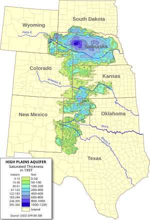
The Ogallala Aquifer is the worlds largest aquifer, covering an area of 450, 000 square kilometres. It is also known as the High Plains Aquifer, and it is used 30% for irrigation purposes and is a drinking water supply to 82% of the population. It is located in the Great Plains of the United States of America.
The Urban Water Cycle (UWC) is a project run by the countries around the North Sea (Germany, Holland, England and Denmark) to tackle the drinking water problem. They all share ideas and solutions about this problem and discuss ways to preserve water for the future.
In Walkerton, Ontario in May of 2008, the local drinking water supply was contaminated by a nearby farm run off into a nearby well with the bacteria E.coli. Around 5000 people of the town were infected. 7 of these people died because the town did not admit to the problem as soon as they should have.
your local community- In British Columbia, 28.5 % of the population uses groundwater for multiple purposes.
Country- In Canada as a whole, 30.3% depend on groundwater for many purposes.
the earth as a whole-
The earth as a whole: Around 20% of the earth relies on groundwater as their freshwater supply.
An artesian well works simply by gravity. An artesian well works because the water is usually flowing from a point of high elevation, it moves through porous rock layers to the surface because of the pressure from the rock.
Human impact on groundwater can contaminate groundwater in various ways- from surface sourses, ground sources and other sources as well. Having landfills and dumps for waste water, leakages in petrol tanks and sewage systems, and the use of pesticides on agriculture can greatly impact the safety of the water supply.
The Ogallala Aquifer is the worlds largest aquifer, covering an area of 450, 000 square kilometres. It is also known as the High Plains Aquifer, and it is used 30% for irrigation purposes and is a drinking water supply to 82% of the population. It is located in the Great Plains of the United States of America.
The Urban Water Cycle (UWC) is a project run by the countries around the North Sea (Germany, Holland, England and Denmark) to tackle the drinking water problem. They all share ideas and solutions about this problem and discuss ways to preserve water for the future.
In Walkerton, Ontario in May of 2008, the local drinking water supply was contaminated by a nearby farm run off into a nearby well with the bacteria E.coli. Around 5000 people of the town were infected. 7 of these people died because the town did not admit to the problem as soon as they should have.
Monday, April 19, 2010
Oh, cool.

This doesn't have to do with Salt Spring Island Water, but it's pretty interesting nonetheless.
Thursday, April 15, 2010
River and Streams Terms
Rivers
Youthful stream –The beginning stages of a river. A matured stream that has returned back to youthful habits due to an uplift or rejuvination.
V-shaped valley- A valley with cross-sectional structure in the shape of a v, usually created by river erosion.
Evapotranspiration- the amount of water evaporation and plant transpiration from the Earth's land to the atmosphere.
Headward Erosion- the lengthening of a young valley or gully by water erosion at the head of the valley.
Vertical Erosion- When the depth of the river is greater than the width, causing erosion to take place on the bed of the river.
Lateral Erosion- When the water erodes the sediments on the stream channel.
Flood Plain- A plain bordering a river that is at possibility of flooding.
Precipitation- the water that has evaporated into the air, after it falls.
Alluvium- Sediment deposited by flowing water in riverbeds, floodplains or deltas.
Meander- A stream that follows a winding, turning course.
Undercut Banks/Slip-off Slopes- Strong flow of water against an Earthen bank that can create cave like forms and overhangs. (Slip off slopes: the low, gentle overhang on the inside of the downside face of a stream.)
Old Age stream- River that has almost reached it's base level, thus making it slow, and gradient and velocity very low.
Levees- natural or artificial wall or slope used to regulate water levels.
Oxbow Lakes- A U shaped body of water created by river that is cut off to make a lake.
Yazoo Streams- A stream that runs parallel to, and sometimes within the floodplain of, a river.
Solution-
condensation- The procedure of moisture (or a gaseous matter) solidifying into a liquid or solid state.
Suspension-
Traction/Saltation- Process of particle transportation by water.
Abrasion/Corrasion The weathering down by boulders and pebbles crashing against the shore rocks or sea cliffs. This can cause undercutting.
Attrition- Boulders or pebbles crashing against the shore themselves breaking.
Evaporation- The process of water turning into a gaseous form- mist/ moisture.
Corrosion- Materials dissolved by seawater.
Hydraulic Action- A form of erosion caused by moving water rushing into a crack in the riverbed, leaving air in it, and acting like a wedge. When the water exits the cracks, they grow bigger.
Water Shed- A ridge of high landing dividing two areas that are drained by different river systems.
Tributaries- A stream. River or glacier that feeds a larger one.
Distributaries- A branch or stream that flows away from the river, and doesn't return to it.
Confluence- A flowing together of two or more streams.
Transpiration- Emission of water vapor through the leaves of plants.
Interfluve- The region of higher land between two rivers of the same level and drainage system.
Divide- Kind of like a watershed- the area of high land that separates draining basins.
Hydrologic Cycle- Another name for “water cycle” the cycle of evaporation, precipitation, etc.
Paired Terraces- Also known as a “matched terrace”, it is two stream terraces that face eachother at opposite sides of the stream from the same elevation and represent same remnants from a floodplain or valley floor.
Alluvial Fan- Cone- shaped deposit of sediments left by a fast flowing river that runs onto a a level plain, valley floor or basin abruptly.
Arcuate Delta- A bowed or curved delta with the convex area facing the water.
Birds foot Delta- A delta with long, projecting branches that spread out like birds talons.
Cuspate Delta- Pointed, shaped by gentle water opposing it.
Estuary- Partially enclosed coastal body of water, usually with a connection to the ocean, where salt and fresh water mix.
Braided Stream- A stream flowing in several channels that weave.
Run off- the water that just runs over the ground, usually after a heavy rainfall.
Groundwater- Water that is found underneath the surface of the earth.
Trellis- a weaved structure of wood usually used to support plant life?
Radial- Branching out in all directions with a common center.
Dendritic- Drainage pattern of a stream or river, like a tree, branching out.
Deranged- To upset/ disturb the arrangement of things
Mature stream- A river with a gradient less steep and slower flowing than a youthful one.
Tuesday, April 13, 2010
Desert 2
GEOGRAPHY 12
DESERT LANDFORMS part 2
Despite the fact that water is the most important agent of erosion in deserts, wind is quite important too.
The action of wind eroding, transporting and depositing sediments is called eolian or aeolian erosion processes.
Wind erosion is common because there is little soil to hold the sand or sediment in place.
Deflation is the large scale removal of sediment by wind.
Abrasion is the process where sand carried by the wind “sandblasts”
rocks
Regions covered in sand are called ergs, or sand seas.
Regions which are bare rock are called gibbers, serir, or regs in Algeria.
Diagram and explain the following:
Deflation hollow or basin:
Created by wind erosion, the wind whips sand at sand-sediment structures periodically thus carving out a hollow.
Barchan- arc-shaped sand ridge/ dune of well-sorted sand, with two “horns” facing the opposite direction of the wind.
Parabolic dunes- Carved and molded dunes do to wind erosion.
rock pedestal- This is the product of wind erosion when small sand sediments carve away at the base of a mound, leaving the harder rock in place, creating a sort of “pedestal.”
arch- Often an enlarged cave or opening carved out by waves or wind.
salt flats- This is what happens when water evaporates, leaving the remnants of salt behind on a plain after a rainfall.
Badland- A landscape full of gullies, carved hillsides and ravines eroded down by wave action into relatively soft rock/ arid climate.
Desert 1
Geography 12
DESERT LANDFORMS
Deserts - def. - arid region characterized by little or no rainfall in which vegetation is scanty or absent unless specially adapted
region where evaporation exceeds precipitation
There are various causes of deserts -
1) Continentality - the desert is far from a body of water or the influence of a
body of water - e.g. Gobi desert
2) High Pressure - in subtropical regions descending air in high pressure belts
prevents moist air masses from entering the area and bringing rainfall
e.g. Sahara
3) Rainshadow- regions on the leeward side of mountains experience dry
conditions due to adiabatic heating of descending air masses e.g. Mojave
4) Cold Ocean currents - on the west coasts of S. America and S. Africa cold
currents create stable air masses that hold very little water vapour - as the
air mass meets the warmer land mass fog forms but there is not enough
water vapour to create precipitation - e.g. Atacama
5) Polar deserts - created by sinking of cold dry air masses - ice is present
on the land although there is little precipitation
DESERT LANDFORMS
Despite the lack or limited amount of precipitation in deserts, water is the major agent of erosion. Rainfall when it comes is brief and intense, and due to the hard rocky surface and limited vegetation tends to quickly run off,
creating flash floods.
Landforms created by water include: (define and draw)
Wadis – Common water-formed features in desert regions. They have steep sides, and don't usually contain flowing water. Most of the damage is done by flash floods.
Playas – Dry lake beds imbedded with clays and silts. After a rainfall, as the water evaporates, it leaves behind remnants of solid salts and such. These dry lake beds are usually found in the centre of inland basins.
Alluvial fans – This is where large sediments previously carried by running water has built up abruptly on level plains, valleys or basins. This usually occurs between mountains, and causes a drop in stream velocity and depth.
Bahada – Linked closely to alluvial fans, this is a gently sloping surface of alluvial materials from the foot of a mountain to the centre of a basin. These are formed by build up of alluvial fans.
Mesa/ Butte – A butte is smaller than a mesa, a flat topped hill with steep sloped sides. A mesa is a bigger version of this, with escarpments marking the sides.
Canyon – A ravine caused by a river, in an area of seldom rainfall.
Because of limited precipitation physical weathering is dominant.
The main physical processes are heating-cooling, freezing-thawing,
and exfoliation.
DESERT LANDFORMS
Deserts - def. - arid region characterized by little or no rainfall in which vegetation is scanty or absent unless specially adapted
region where evaporation exceeds precipitation
There are various causes of deserts -
1) Continentality - the desert is far from a body of water or the influence of a
body of water - e.g. Gobi desert
2) High Pressure - in subtropical regions descending air in high pressure belts
prevents moist air masses from entering the area and bringing rainfall
e.g. Sahara
3) Rainshadow- regions on the leeward side of mountains experience dry
conditions due to adiabatic heating of descending air masses e.g. Mojave
4) Cold Ocean currents - on the west coasts of S. America and S. Africa cold
currents create stable air masses that hold very little water vapour - as the
air mass meets the warmer land mass fog forms but there is not enough
water vapour to create precipitation - e.g. Atacama
5) Polar deserts - created by sinking of cold dry air masses - ice is present
on the land although there is little precipitation
DESERT LANDFORMS
Despite the lack or limited amount of precipitation in deserts, water is the major agent of erosion. Rainfall when it comes is brief and intense, and due to the hard rocky surface and limited vegetation tends to quickly run off,
creating flash floods.
Landforms created by water include: (define and draw)
Wadis – Common water-formed features in desert regions. They have steep sides, and don't usually contain flowing water. Most of the damage is done by flash floods.
Playas – Dry lake beds imbedded with clays and silts. After a rainfall, as the water evaporates, it leaves behind remnants of solid salts and such. These dry lake beds are usually found in the centre of inland basins.
Alluvial fans – This is where large sediments previously carried by running water has built up abruptly on level plains, valleys or basins. This usually occurs between mountains, and causes a drop in stream velocity and depth.
Bahada – Linked closely to alluvial fans, this is a gently sloping surface of alluvial materials from the foot of a mountain to the centre of a basin. These are formed by build up of alluvial fans.
Mesa/ Butte – A butte is smaller than a mesa, a flat topped hill with steep sloped sides. A mesa is a bigger version of this, with escarpments marking the sides.
Canyon – A ravine caused by a river, in an area of seldom rainfall.
Because of limited precipitation physical weathering is dominant.
The main physical processes are heating-cooling, freezing-thawing,
and exfoliation.
Subscribe to:
Posts (Atom)